|
|
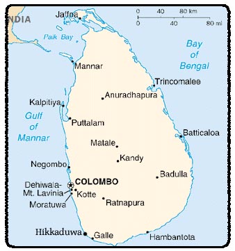
Location:
Southern Asia, island in the Indian
Ocean, south of India
Geographic coordinates: 7 00 N, 81 00 E
Map references: Asia
Area: total: 65,610 sq km
land: 64,740 sq km
water: 870 sq km
Area - comparative: slightly larger than West Virginia
Land boundaries: 0 km
Coastline: 1,340 km
Maritime claims: territorial sea: 12 nm
contiguous zone: 24 nm
exclusive economic zone: 200 nm
continental shelf: 200 nm or to the edge of the continental
margin
Climate: tropical monsoon; northeast monsoon (December
to March); southwest monsoon (June to October)
Terrain: mostly low, flat to rolling plain; mountains in south-central
interior
Elevation extremes: lowest point: Indian Ocean 0 m
highest point: Pidurutalagala 2,524 m
Natural resources: limestone, graphite, mineral sands,
gems, phosphates, clay, hydropower
Land use: arable land: 13.86%
permanent crops: 15.7%
other: 70.44% (2001)
Irrigated land: 6,510 sq km (1998 est.)
Natural hazards: occasional cyclones and tornadoes
Environment - current issues: deforestation; soil erosion;
wildlife populations threatened by poaching and urbanization; coastal
degradation from mining activities and increased pollution; freshwater
resources being polluted by industrial wastes and sewage runoff; waste
disposal; air pollution in Colombo
Environment - international agreements: party to: Biodiversity,
Climate Change, Climate Change-Kyoto Protocol, Desertification, Endangered
Species, Environmental Modification, Hazardous Wastes, Law of the Sea,
Ozone Layer Protection, Ship Pollution, Wetlands
signed, but not ratified: Marine Life Conservation
Geography - note: strategic location near major Indian Ocean sea lanes
|
|
Population: 20,064,776
note: since the outbreak of hostilities between
the government and armed Tamil separatists in the mid-1980s, several hundred
thousand Tamil civilians have fled the island and more than 200,000 Tamils
have sought refuge in the West (July 2005 est.)
Age
structure: 0-14 years: 24.5% (male 2,508,384/female 2,397,986)
15-64 years: 68.4% (male 6,658,765/female 7,059,468)
65 years and over: 7.2% (male 670,813/female 769,360)
(2005 est.)
Median age: total: 29.44 years
male: 28.38 years
female: 30.51
years (2005 est.)
Population growth rate: 0.79%
(2005 est.)
Birth rate: 15.63 births/1,000 population
(2005 est.)
Death rate: 6.49 deaths/1,000 population
(2005 est.)
Net migration rate: -1.27 migrant(s)/1,000
population (2005 est.)
Sex ratio: at birth: 1.05
male(s)/female
under 15 years: 1.05 male(s)/female
15-64 years: 0.94 male(s)/female
65
years and over: 0.87 male(s)/female
total population:
0.96 male(s)/female (2005 est.)
Infant mortality rate:
total: 14.35 deaths/1,000 live births
male: 15.57
deaths/1,000 live births
female: 13.07 deaths/1,000
live births (2005 est.)
Life expectancy at birth:
total population: 73.17 years
male: 70.6 years
female: 75.86 years (2005 est.)
Total fertility
rate: 1.85 children born/woman (2005 est.)
HIV/AIDS - adult prevalence rate: less than 0.1% (2001 est.)
HIV/AIDS - people living with HIV/AIDS: 3,500 (2001 est.)
HIV/AIDS - deaths: less than 200 (2003 est.)
Nationality:
noun: Sri Lankan(s)
adjective: Sri Lankan
Ethnic groups: Sinhalese 73.8%, Sri Lankan Moors
7.2%, Indian Tamil 4.6%, Sri Lankan Tamil 3.9%, other 0.5%, unspecified
10% (2001 census provisional data)
Religions:
Buddhist 69.1%, Muslim 7.6%, Hindu 7.1%, Christian 6.2%, unspecified 10%
(2001 census provisional data)
Languages: Sinhala
(official and national language) 74%, Tamil (national language) 18%, other
8%
note: English is commonly used in government
and is spoken competently by about 10% of the population
Literacy:
definition: age 15 and over can read and write
total population:
92.3%
male: 94.8%
female:
90% (2003 est.)
|
|
|
|
|
|
|
|
|
|
Country
name: conventional long form:
Democratic Socialist Republic of Sri Lanka
conventional short form: Sri Lanka
former: Serendib, Ceylon
Government type: republic
Capital: Colombo; note - Sri Jayewardenepura Kotte
is the legislative capital
Administrative divisions: 8 provinces; Central, North
Central, North Eastern, North Western, Sabaragamuwa, Southern, Uva,
Western; note - North Eastern province may have been divided in two
- Northern and Eastern
Independence: 4 February 1948 (from UK)
National holiday: Independence Day, 4 February (1948)
Constitution: adopted 16 August 1978, certified 31
August 1978; new constitution proposed in 2002
Legal system: a highly complex mixture of English common
law, Roman-Dutch, Muslim, Sinhalese, and customary law; has not accepted
compulsory ICJ jurisdiction
Suffrage: 18 years of age; universal
Executive branch: chief of state: President Mahinda
Rajapakshe
head of government: President Chandrika Bandaranaike
KUMARATUNGA
cabinet: Cabinet appointed by the president in consultation
with the prime minister
elections: president elected by popular vote for a
six-year term; election last held 21 December 1999 (next to be held
NA December 2005)
Legislative branch: unicameral Parliament (225 seats;
members elected by popular vote on the basis of a modified proportional
representation system by district to serve six-year terms)
elections: last held 2 April 2004 (next to be held
by 2010)
election results: percent of vote by party or electoral
alliance - SLFP and JVP 45.6%, UNP 37.83%, TNA 6.84%, JHU 5.97%, SLMC
2.02%, UPF 0.54%, EPDP 0.27%, others 0.93%; seats by party or electoral
alliance - SLFP and JVP 105, UNP 82, TNA 22, JHU 9, SLMC 5, UPF 1, EPDP
1
Judicial branch: Supreme Court; Court of Appeals; judges
for both courts are appointed by the president
Political parties and leaders: All Ceylon Tamil Congress
or ACTC [KUMARGURUPARAM]; Ceylon Workers Congress or CWC [Arumugam THONDAMAN];
Communist Party or CP [D. GUNASEKERA]; Democratic United National (Lalith)
Front or DUNLF [Shrimani ATULATHMUDALI]; Eelam People's Democratic Party
or EPDP [Douglas DEVANANDA]; Eelam People's Revolutionary Liberation
Front or EPRLF [Suresh PREMACHANDRAN]; Janatha Vimukthi Perumuna or
JVP [Tilvan SILVA]; National Heritage Party or JHU [Tilak KARUNARATNE];
National Unity Alliance or NUA [Ferial ASHRAFF]; People's Liberation
Organization of Tamil Eelam or PLOTE [leader NA]; Sihala Urumaya or
SU [leader NA]; Sri Lanka Freedom Party or SLFP [Chandrika Bandaranaike
KUMARATUNGA]; Sri Lanka Muslim Congress or SLMC [Rauff HAKEEM]; Sri
Lanka Progressive Front or SLPF [P. Nelson PERERA]; Tamil Eelam Liberation
Organization or TELO [SABARATNAM]; Tamil National Alliance or TNA [R.
SAMPANTHAN]; Tamil United Liberation Front or TULF [V. ANANDASANGAREE];
United National Party or UNP [Ranil WICKREMASINGHE]; Up-country People's
Front or UPF [P. CHANDRASEKARAN]; several ethnic Tamil and Muslim parties,
represented in either Parliament or provincial councils
Political pressure groups and leaders: Buddhist clergy; labor unions;
Liberation Tigers of Tamil Eelam or LTTE [Velupillai PRABHAKARAN](insurgent
group fighting for a separate state); radical chauvinist Sinhalese groups
such as the National Movement Against Terrorism; Sinhalese Buddhist
lay groups
International organization participation: AsDB, C, CP, FAO,
G-15, G-24, G-77, IAEA, IBRD, ICAO, ICC, ICFTU, ICRM, IDA, IFAD, IFC,
IFRCS, IHO, ILO, IMF, IMO, Interpol, IOC, IOM, ISO, ITU, MIGA, MINURSO,
MINUSTAH, MONUC, NAM, OAS (observer), ONUB, OPCW, PCA, SAARC, SACEP,
UN, UNCTAD, UNESCO, UNIDO, UPU, WCL, WCO, WFTU, WHO, WIPO, WMO, WToO,
WTO
Diplomatic representation in the US: chief of mission:
Ambassador Bernard GOONETILLEKE
chancery: 2148 Wyoming Avenue NW, Washington, DC 20008
telephone: [1] (202) 483-4025 (through 4028)
FAX: [1] (202) 232-7181
consulate(s) general: Los Angeles
consulate(s): New York
Diplomatic representation from the US: chief of mission:
Ambassador Jeffrey J. LUNSTEAD
embassy: 210 Galle Road, Colombo 3
mailing address: P. O. Box 106, Colombo
telephone: [94] (11) 244-8007
FAX: [94] (11) 243-7345
Flag description: yellow with two panels; the smaller hoist-side panel
has two equal vertical bands of green (hoist side) and orange; the other
panel is a large dark red rectangle with a yellow lion holding a sword,
and there is a yellow bo leaf in each corner; the yellow field appears
as a border around the entire flag and extends between the two panels
|


